|
|
|
|
||||||||
|
Lobster
Fishing on the North Shore The Maritime Provinces, Nova
Scotia, Prince Edward Island (P.E.I.)
and New Brunswick, are located in eastern Canada on the Atlantic Ocean seaboard.
Maritimers have been harvesting the bounty of the sea from villages along
the miles of these shorelines for generations.
The American lobster, or as it’s called in this neck of the woods, the
“Atlantic lobster”, is a favoured dish that has been fished from these seas
for hundreds of years. Warm waters and warm people
make the Northumberland Strait area of Nova Scotia famous! All along the north
shore, tiny fishing villages dot the coastline, where the gently rolling hills
meet the sparkling blue waters of the Northumberland Strait.
This body of water separating Nova Scotia and Prince Edward Island makes
up a large part of the southern
Gulf of St. Lawrence
and is an ideal habitat for the tasty lobster that is served up in restaurants
and at church suppers all along this shore.
Along the north shore you will
find many fishing
ports where families, friends and neighbors fish side by side season after
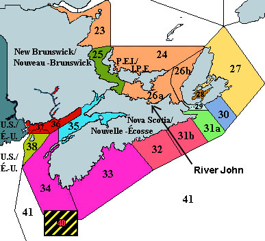
season. Lobster Fishing Area 26A,
which covers Antigonish, Pictou, Colchester, and a small part of Cumberland
County, is one of the five designated areas making up the southern Gulf of St.
Lawrence district. Around the River
John area there are three busy lobster fishing ports:
Toney
River, Skinner’s Cove and Cape John.
Besides the busy fishing ports located along the North Shore there are a number of processing plants that clean, package and ship the lobster around the world. Arisaig Fisheries Ltd is one such plant. The southern Gulf of St.
Lawrence, includes the waters along the eastern shore of New Brunswick, the
north shore of Nova Scotia (including eastern Cape Breton) and the waters
surrounding Prince Edward Island, and is estimated to be 16, 410 km2
in size. Home to five Lobster Fishing
Areas (LFAs), the southern Gulf of St. Lawrence is one of the many large
districts in the Maritimes that has a thriving lobster industry. LFAs 23, 24, 25, 26A and 26B are the districts that make up the southern Gulf of St. Lawrence. The fisheries management regime for the southern Gulf area is based on these five LFAs, as well as two major fishing seasons, two minimum carapace sizes at capture, and two numbers of traps/fisher. (As of the year 2000)
Map from Department of Fisheries and Oceans website: www.gfc.dfo.ca LFA 23 LFA 24 LFA 25 LFA 26A: LFA 26B Interesting Facts!
This area takes in the region
from Pugwash, Cumberland County to Havre Boucher, Antigonish County as well as
eastern Prince Edward Island. In
the Nova Scotia region of LFA 26A the 351 licensed lobster fishermen (175 of
them in Pictou County) landed 3.5 million pounds of lobster worth a value of
$18.6 million in the 1999 season. FACTS Legal size In LFA 26A a lobster’s carapace (hard shell that covers the lobster’s
body) must measure 66.7 mm (two and five-eighths inches) in order for it to be
of legal size. However, some
regions in this district such as the fishing ports west of Cape John and
east of Lismore have increased this size further to 70mm (two and three quarter
inches). In 2001 the minimum
carapace size for LFA 26A will be increased to 67.5mm. For a lobster to be legal it also cannot be carrying eggs, and it must have
a 'pristine' flipper to the right of the center flipper, showing no V-notch,
grooves or indents of any kind. The Department of Fisheries and Oceans Canada has introduced measures such as these to aid in the conservation of the lobster population of the southern Gulf. Based on 1999 data from the Department of
Fisheries and Oceans Canada Fishing
Ports of Northern Nova Scotia Here are just some of the many
fishing ports located on the Northumberland Strait in northern Nova Scotia: Antigonish County
Pictou County
Colchester and Cumb
The village of River John is situated
on a river, not actually on the ocean, therefore there are no fishing ports located in
the village. However, there are
three wharfs located outside the village at Cape John, Skinner’s Cove and
Toney River. The majority of
fishermen from the village and the surrounding area fish at one of these three
wharfs. During lobster season the
fishermen are busy from dawn to dusk with numerous tasks.
Whether it be maintaining the boat, the wharf, or equipment, selling
lobster or fishing for it, there is always something for a fishermen to do
during the lobster season. One of these busy fishermen is Ronnie
Heighton who fishes at the Cape John wharf. He has been fishing with his boat
the “Annett Marie” since 1965, and has spent more then a decade as the
president of the Fishermen’s Association.
The Fishermen’s Association is a council that acts as a liaison
between the Department of Fisheries and the fishermen in the area, and has been
around since the 1970’s. The Association covers the area from Pugwash to
Lismore and is one of four associations in the southern Gulf. There are 9 board
members and a large number of general members who represent the many different
fishing ports along the North Shore. They
meet when it is needed to discuss various issues. Cape John Wharf The River John empties out into John Bay and
is sheltered from the Northumberland Strait by a 10km stretch of land called
Cape John. At the very end of the
Cape facing the bay sits the L-shaped wharf where 15 boats are moored. On a
windy day it is fun to drive down to the wharf and watch the large waves
crashing up against the breakwater. On
a sunny day the beach nearby is a great place for a picnic or a swim. From the
end of the Cape you can see the whole bay and the surrounding area. The Cape
John Harbour Authority is presently working on replacing the 50-year old wharf. Skinner’s Cove Wharf Skinner’s Cove wharf is located on the
“Backshore” road, a gravel road that connects Melville Corner to Cape John.
The clear blue waters of the Northumberland Strait wash the shores and
high, jagged cliffs rise up to meet the skies.
It is a favorite place for locals to swim, walk and picnic.
On clear days one might be able to catch a glimpse of the ferry crossing
from Caribou to Prince Edward Island. The
twelve boats at Skinner’s Cove are moored to two docks, separated by a small,
narrow channel. Toney River Wharf Toney River, a community located between Pictou and River John on the Sunrise Trail (Route 6), has one of the most photographed wharfs along the Northumberland Strait. If you want to see what goes on at a wharf during lobster season stop by Toney River and have a look. The boats start coming in usually between 10:00am and 2:00pm. You can walk either side of the wharf and watch as the lobsters are weighed and crated. You might even be lucky enough to buy some for your dinner! |
||||||||||
|
|